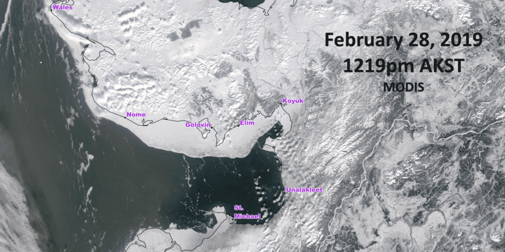
Sea ice extent has been reduced to almost nothing due to the latest series of storms that hit several communities in the Bering Strait region. Open water can now be seen from the shores of Unalakleet, Shishmaref, and elsewhere along the west coast of Alaska, a sight that is historically abnormal for this time of year.
“Ice moving out from Diomede, mostly open water to the north of St. Lawrence Island now. It’s really a remarkable situation that we’re in at this point.”
Rick Thoman is a climate specialist with the Alaska Center for Climate Assessment and Policy (ACCAP). He says 15 separate storms have buffeted the Bering Sea in the last five weeks, which continue to erode sea ice.
“Every additional storm, every additional day that we have of these south-to-southeast winds, is another day that will chew away at what ice there is and keep any new ice from forming or any existing ice from strengthening.”
These sea ice conditions harken back to last year at this time in the Norton Sound area. Thoman says currently the sea ice is “uncannily similar” to the March 2018 extent.
With more open water, the concern for most near the Bering Sea is coastal flooding. According to local reports from early February, residents in Shishmaref saw the winds blow a 20-foot pile of ice right up to their shoreline, near the community’s road. In Kotlik, Philomena Keyes observed flooding impact houses in her community after a Bering Sea storm caused high water levels to back up along the Yukon River from the southern Norton Sound.
According to Thoman, at that same time in mid-February, Unalakleet had storm surges of ten feet along their coastline.
Today, the National Weather Service expects elevated water levels to again impact the west coast of the state, including the Southern Seward Peninsula coast and Norton Sound area. According to the weather satellite image from yesterday afternoon, Thoman says there is little sea ice left in southern and eastern Norton Sound, with open water now spreading to Norton Bay between Shaktoolik and Koyuk.
“Coastal flooding is certainly a possibility with these storms and all the open water we have. The big complicating factor this time of year is ice being so mobile right now, can be moved around, and so the impacts in any one place are very difficult to determine… can get slush berms form very quickly that can help or hurt.”
And residents in Western Alaska won’t be the only ones trying to minimize the hurt or damages caused by the current state of sea ice in the region.
The 2019 Iditarod sled dog race begins this weekend, with 52 mushers set to make the 1,000-mile journey from Willow to Nome. Once the front runners reach the Norton Sound coast, in a week or so, Iditarod staff have instructed them to follow the trail overland rather than cross the unstable sea ice.
Thoman agrees with their decision; he says avoiding travel over the sea ice at this point is probably “the point of least regret.”
Image at top: A satellite image taken of the Norton Sound region’s sea ice extent on February 28, 2019. Photo provided by Rick Thoman (ACCAP).


