In a community that has had three different airport locations, been relocated once already and could be moved again in the future, coastal erosion from winter storms is a real threat to Shaktoolik.
That’s why it is one of three communities currently involved in testing out a storm surge sensor project organized by the University of Alaska Fairbanks. KNOM’s Davis Hovey saw the sensor in Shaktoolik for himself and has this report:
I’m riding down Shaktoolik’s main road in a brand new truck, with three long-time residents. As the road turns into beach, the President of the Native Village of Shaktoolik, Matilda Hardy, points out a dead walrus laying on the sand, which she says has been there since the summer. Hardy mentions that besides tons of driftwood, many interesting things, like spears or old bed frames, can be found on this extensive beach.
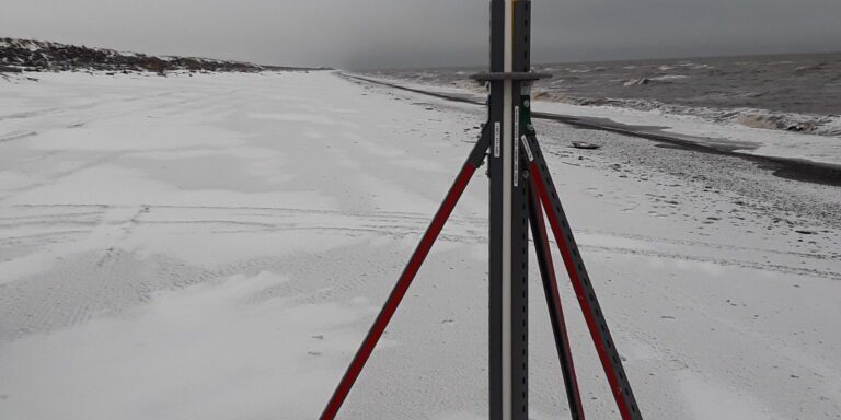
“It goes all the way down to tripod and a little past tripod, tripod meaning it’s another tripod past the old site. We are going to the first tripod, which they put for the tide mark,” said Hardy.
As Hardy explained, we are heading towards a UAF storm surge sensor mounted on a tripod, which is not to be confused with the other tripod, originally setup by a commercial fisherman years ago but has since blown away.
When the truck comes to a stop, one of the other passengers, Sophia Katchatag, and I hop out. Facing southwest towards the Bering Sea a half-mile outside of town, we’ve reached our destination.
“Well it’s a gray and red tripod which I think is at least three feet down, that’s pretty sturdy,” explained Katchatag.

Besides fulfilling her regular job title with the Shaktoolik IRA, Katchatag is considered an environmental coordinator with the UAF storm surge research project.
Essentially, she checks on the tripod sensor whenever she gets an email instructing her to do so.
“I go down towards end of dump with the iPad and collect the data; then, I come back to my work with Wi-Fi so I can email it to him (Kasper),” said Katchatag.
Jeremy Kasper is the principal investigator with this UAF project, which is sponsored by Alaska Ocean Observing System (AOOS). He also emails Katchatag her instructions.
Kasper’s project team has had sensors set up in Shishmaref, Kivalina, and Shaktoolik for months. He says the sensors will continue to collect data on water levels and storm surge for as long as they last:
“So basically, we have a pressure sensor that’s out on the beach in each of these communities. It’s continuously recording the elevation of the water above the sensor, and we’ve got it set so when a storm comes in and it goes over a certain threshold, then it (the sensor) starts recording more quickly. Then you get a measure of the storm surge plus wave setup and then wave height.”
In other communities, those sensors are already battle-worn. Earlier this month (Veterans Day weekend), Shishmaref was hit by a storm that eroded away sections of their main road, which leads to the community’s landfill.
Shaktoolik hasn’t seen any major winter storms so far this year, but Katchatag recalls one storm years ago that was significant.
“In 2013, the river had gotten up, basically right behind the homes here, and that next morning, that’s all you could see was water, basically, everywhere behind here. No land, just water. And the waves were just… scary, they were huge, they were rolling in, but luckily, we didn’t get flooded.”

This summer, the community constructed a berm to put a barrier between themselves and the ocean storms, but there is currently no evacuation road leading out of Shaktoolik. Katchatag says construction on the road is set to begin next summer, which will end at the hills outside of the community:
“The only way that they would be able to make it to the foothills right now, would be through the beach, and if there is a storm, it’s kind of impossible to get to the foothills through the beach, because the waves are covering the beach, so we wouldn’t be able to go there. My only other thought would be, everyone go in their boats, pack up their boats and head up, because when there is a storm, there’s also the river rising on this side.”
With the future probability of winter storms and the threat of flooding and erosion in coastal communities like Shaktoolik, Kasper’s hope is that the storm surge sensors will contribute to more accurate weather and storm forecasts, which could help community preparedness.
“The Fairbanks forecast office, what they typically do is compile community observations on how high the water level came in, whereas with this system, if we get the data back, then we actually have surveyed in these systems using GPS, so we have a very accurate measure of the total water level, which helps out with future storm kind of scenarios.”
After the trial run of the project is over, then the data will be organized and analyzed. Kasper says if the UAF storm surge sensor research proves to be fruitful, then newer and better technology will be used next time.
According to Kasper, the sensor-collected data will be used to generate the National Oceanic and Atmospheric Administration (NOAA)’s weather forecasts.
Image at top: UAF’s storm surge sensor set up in Shaktoolik to gather data on wave levels and more for NOAA weather forecasts. Photo Credit: Davis Hovey, KNOM (2017).


