

The Climate Assessment and Proactive Resilience Initiative (CAPRI) has chosen Nome as the focal point for a new project. Nome’s unique geographical and socio-economic position, particularly its expanding port facilities, makes it a critical area for studying the impacts of climate change and testing resilience strategies. The team seeks to collect data, paired with indigenous knowledge, to update tools used to track changes to the environment.
Ukallaysaaq Okleasik serves as a community liaison for CAPRI. Setting the scene for why CAPRI’s research is so vital as the region undergoes massive changes, Okleasik recalled memories from 2008 when the George W. Bush Administration collected bids worth $2.7 billion in oil leases in the Chukchi Sea.
“People may remember the amount of concern raised by our native communities about how unprepared we were for offshore oil development, lack of studies, lack of integration with subsistence worries about oil spills and ice. And so there was a huge influx of research at that time to say, ‘how do we address all these gaps?’”
The initiative is spearheaded by the University of New Hampshire’s Coastal Response Research Center and supported by NOAA’s Office of Response and Restoration. The funding for this effort came from ADAC-Arctic Center of Excellence (a DHS funded center based at the University of Alaska Anchorage). Nancy Kinner from the University of New Hampshire explained the choice of Nome for deploying CAPRI’s visualization tools.
“Nome is facing more storms, Nome is facing a major change with port development, there are so many things that are embodied here in Nome, that, really, it brings together a lot of different challenges,” Kinner said.
This makes Nome an ideal location for building on existing data visualization technologies such as ERMA® (Environmental Response Management Application) as well as to create new artistically rendered 3D models and coastal uses maps.

ERMA was developed by the NOAA and the University of New Hampshire with help from the U.S. Environmental Protection Agency, U.S. Coast Guard, and U.S. Department of the Interior. The tool integrates various environmental data layers to provide a comprehensive visual representation of data. The ability to layer information can make for more powerful insights, according to Kinner.
“ERMA is just layers of different datasets that are shown visually on maps. It might be layers that show where there’s a critical bird habitat, it might be layers that show where the ice is during an oil spill, where it’s been before, where the oil is predicted to go today or 48 hours from now. So what people can do there is they can then put these layers on top of each other to see where things overlap,” Kinner said.
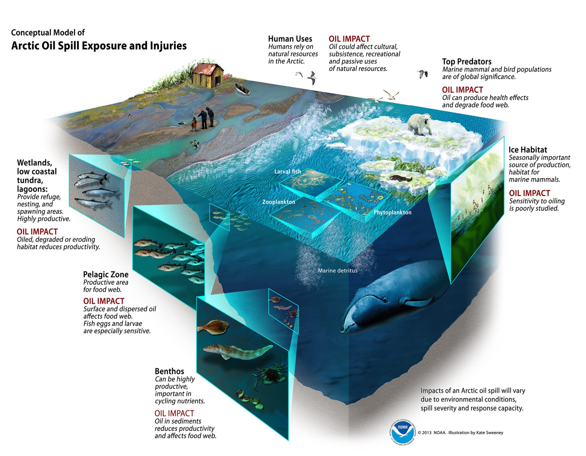
The artistically rendered 3D Conceptual Models serve another vital purpose by vividly depicting potential environmental scenarios and their impacts. These models are designed to evoke an emotional response and enhance public understanding of the direct impacts of climate issues, thereby influencing policy and community preparedness.
“It’s just like looking at a painting, that’s very moving. And it shows you the relationships,” Kinner said.
Another tool, coastal uses maps, are used to identify overlapping areas of interest among different stakeholders, essential for conflict resolution and planning. Kinner described how these maps have previously facilitated discussions in other regions, allowing stakeholders to visually negotiate space and resources, thus avoiding potential conflicts.
Okleasik, born and raised in Nome, emphasized the importance of local engagement. This approach not only ensures the incorporation of scientific data but also integrates indigenous knowledge and community perspectives into the project’s framework.
“When you don’t have indigenous knowledge or you don’t have community level input, the models can be really off. The change is happening, but to bring our voices and to bring our input and our concerns into those things, makes the models better,” Okleasik said.
As CAPRI moves forward in Nome, the project aims to not only address the immediate impacts of climate change but also set a benchmark for how other Arctic and coastal communities can use similar technologies to tackle environmental challenges.


