Church services and a flight arriving into Nome were canceled on Sunday due to a storm that’s affecting much of Western Alaska.
It was the first day of winter storm warnings that are expected to continue through Tuesday morning (Nov. 14) according to the National Oceanic and Atmospheric Administration.
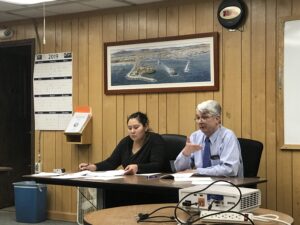
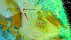
Edward Plumb is a meteorologist at the National Weather Service in Fairbanks. He said the storm will bring a variety of weather conditions to the region, which began with strong winds on Sunday.
He said gusty winds will affect areas surrounding the Bering Strait and some isolated locations
“Whales already came in this morning, Sunday morning, with the gusts to 67 mph” he said. “There in Nome, wind gusts right now are about 40 to 50 mph.”
Wales and Nome had high winds but were surpassed by gusts in Cape Lisburne which reached 85 mph.

The forecast calls for heavy snow Sunday night into Monday morning. Communities north of Nome can expect up to a foot of snow, Plumb said, but most communities can expect between five and eight inches.
He said winds will shift directions on Monday night which will cause water levels to rise several feet above the high tide lines along the Bering Sea and Chukchi Sea coasts.
“With the elevated water and waves washing up, we’re gonna see some minor flooding and likely some beach erosion,” Plumb said. “Up in the Chukchi Sea, we’re not expecting any flooding, but just to have high surf [advisories] kind of, causing some erosion issues there.”
Wales and Nome had high winds but were surpassed by gusts in Cape Lisburne which reached 85 mph.
This is likely the most powerful storm to hit the region since Typhoon Merbok last year, Plumb said, but it won’t be anything like it. He said this storm is minor flooding, and that NWS doesn’t expect any impacts to buildings or structures during the storm.
“After that, you’re gonna see quite a cool down there in Western Alaska,” Plumb said. “The winds are going to shift to the north northwest and bring much cooler air.”
For the most current weather information in your area visit the National Weather Service website or visit their social media.
Photo at top: A nine in the morning, snow flurries began outside of KNOM studios. (Scotty Campbell, KNOM)