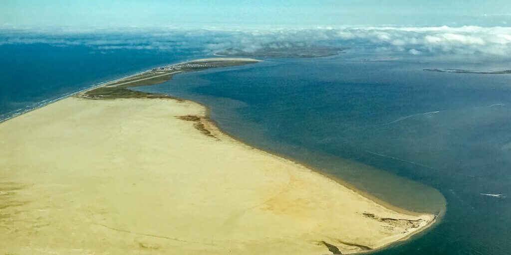
The community of Shishmaref is trying to expand to the mainland as erosion takes more of the village every year. Residents voted on a site in 2016, but there’s still a lot of planning and research to be done before that can be determined viable.
On the night before the summer solstice, a half dozen workers take advantage of the long, midnight-sun hours to continue working on the Shishmaref school. The school needs to expand so that the students no longer have to attend class in temporary trailers during the harsh winter months.
“We’re not a community that’s dying. You might think because of the storms and what-not, you would think that peoples would move away from here.”
Fred Eningowuk is the vice-mayor of Shishmaref. He refers to the erosion and brutal fall storms that have destroyed homes over the years, erased the island’s fresh water sources, and now threaten some of its essential roads. The homes are crowded together, and some residents told KNOM they’re worried about the entire village catching fire. Despite that, he says, people are still moving to the island community and growing their families.

Shishmaref is a sand-barrier island in the Chukchi Sea, separated from the Seward Peninsula by the Shishmaref lagoon. In 2016, the community voted to move to the mainland, to an area called West Tin-Creek Hills.
But Enigowuk doesn’t talk about village re-location.
“We removed the word ‘relocation’ from our community and changed that to ‘expansion.’”
Eningowuk says it’s too difficult to get funding for a community that everyone is expecting to relocate.
And whether they can do that is a “matter of feasibility.” That’s how DOT Project Lead Albert Beck puts it.
“Our survey crews will be going out to Shishmaref, surveying the lagoon floor to get a contour of what’s under the water. That will help us to identify the channels, and we can also use that data to help model storm surges.”
That data, Beck says, can then be used to help the community and planning agencies make decisions.
In mid-July, DOT expects to begin that bathometric survey of the lagoon.
“The survey would help identify what would it take to provide a land-access point, referring to more of, like, a road or a causeway. Or in the case of, if that’s not feasible, how would you get there via water? And then what would your limitations be on the watercraft to get to the mainland?”
Beck says the timeline is somewhat uncertain depending on weather but hopes it would be done within 4-6 weeks. Beck also expects more cultural and archeological work to be done on Sarichef Island so that when improvements or relocations need to be done, those are already known.
Beck explains that next the DOT would have to see what the feasibility is like for a road between the port, the potential community, and the potential gravel source: Ear Mountain. And it still remains to be seen if Ear Mountain is a good source for materials. For now, there is no date set for that exploration.

But in the meantime, the village has needs now.
FEMA funds are now available for the landfill road to be repaired after being washed out in a 2013 storm. The road is currently buffered by sand that was eroded in large chunks by that storm, and the erosion continues now. From the air, it looks like someone took a giant bite out of the road in one section, where erosion leaves just a sliver that locals say often gets flooded or washed out, making travel dangerous or impossible.
Daniel Ademcyzk is the Maintenance Operations Manager for the Department of Transportation in Fairbanks. He says construction on the road is expected to begin in August and be done by early October.
“We’ve been working with them to get them to replace the lost shore-line with rock that will help protect the landfill road from any future storms or wave action, and then, we’ll be using some surfacing to resurface some of the roadway and to fix any of the washed areas on the surface of the road.”
Shishmaref, unlike other villages around the state, was lucky this year. They didn’t suffer any large-scale damage or erosion from late winter and spring storms. But the threat of erosion continues to wear on while the village continues to grow. If they do get a storm, the current church and school aren’t big enough to hold everyone if they need to evacuate.
And the community doesn’t want to see their village become completely insignificant, either. Eningowuk says the location is ideal for marine mammal hunting, and it could be a spring camp; conditions on the mainland are too warm for rendering seal oil and drying meat.
But that idea doesn’t come without challenges.
“My main concern would be out spring hunting. How are we going to cross the ice when it gets real dangerous?… With everybody not economically stable, some won’t be able to afford to come down here. We’re just a walking distance to our meat racks right now.”
Life will look different as the island gets smaller and if the community does expand. But Eningowuk says change isn’t new.
“We the Inupiaq have been adapting for thousands of years, so eventually, we are going to be forced to adapt. One way or another, we’re going to get down here and still continue our subsistence way of life.”
Image at top: An aerial view of Sarichef Island (and, in the distance, the community of Shishmaref), June 2019. Photo: Emily Hofstaedter, KNOM.


