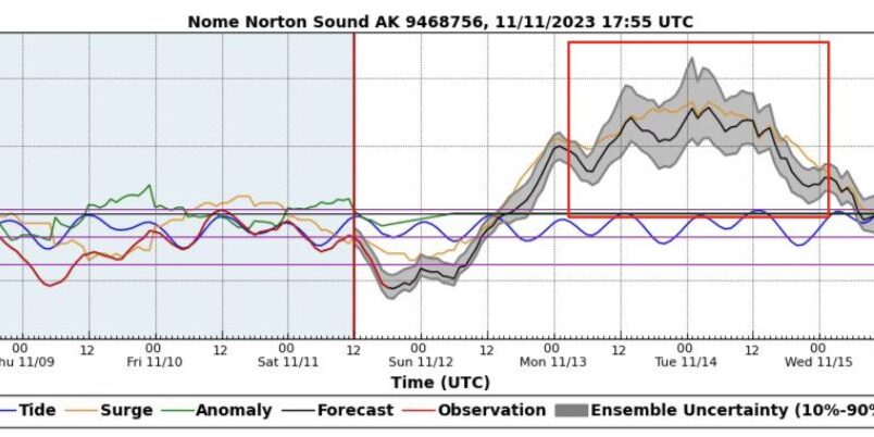
A storm slamming Western Alaska is expected to continue through tomorrow night (Tues, Nov 14).
Nome has now had two days of intense winds and heavy snowfall that is part of a winter storm expected to continue through tomorrow morning according to the National Oceanic and Atmospheric Administration.
Snow showers have blanketed Nome with over half a foot of snow and precipitation is expected to stay as snow through late tonight. A shift in wind direction tonight will cause water levels to rise several feet along the Bering Sea and Chukchi Sea coasts.
National Weather Service meteorologist Jonathan Chriest said he expects waters along the Bering Sea and Chukchi Sea coasts reached their peak height around noon today (Monday), but said elevated water levels will continue through tomorrow.
“[They will] remain about two to three feet above the normal high tide line through late tonight, then decrease to normal levels through tomorrow afternoon.”
Tomorrow night, Chriest said another storm is moving into the Bristol Bay area and its drawing winds from the storm happening now.
“We’re expecting northeast winds picking up tomorrow night up to about 30 miles per hour sustained with gusts up to 50 miles per hour from the north, and then switching over to the northwest through the day.”
Chrieset said heavy winds are expected to last into Thursday morning and will bring blowing snow and low visibility.
Photo at top: Water levels are expected to be highest in Nome on Monday evening. The water is expected to be as much as four feet above the normal high tide line. (NOAA, used with permission)


