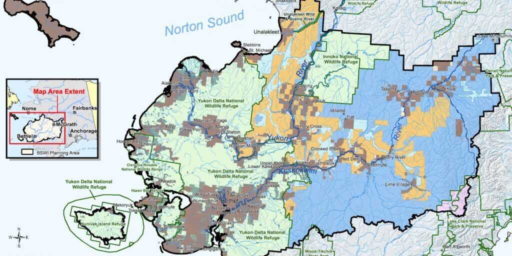
A final proposal introduced by the Bureau of Land Management (BLM) earlier this month would make more than 13 million acres of public lands in the Western Bering Sea region open to development. As KNOM reports, dozens of Alaska Native Tribes say their concerns haven’t been adequately addressed in the proposal.
The new and final plan would replace previous land management plans that have been in place since the 1980’s. As BLM Alaska State Director Chad Padgett explained, the proposal has been in the works since 2013.
“BLM under the federal land management policy act is compelled to update land planning, every so often as land patterns change, and as management prescriptions change, things like that.”
– Chad Padgett
The big change comes for the publicly managed lands in the Bering Sea Western Interior planning area. It’s an area nearly twice the size of Maryland and includes many parts of the Eastern Norton Sound region: including lands used by and around the communities of Elim, Koyuk, Shaktoolik, Unalakleet, Stebbins, and St. Michael.
It stretches from south of Buckland, down to Aniak, and towards the Interior past McGrath.
Under this final proposal, most of those lands would be open for future development, like mining.
The potential for development makes Eugene Paul, the Tribal Chief of Holy Cross, uneasy. His community is basically surrounded by the BLM lands in question, lands that they’re dependent on for all kinds of subsistence moose hunts, berry picking, and tributaries for freshwater fish like pike.
“Those are some of the resources that we really depend on to help our community. If they open up some of that part, that’s going to really put a damper on some of our resources that we rely on.”
– Eugene Paul
Paul says most of the community of only 170 people depend on subsistence as a main part of their diet.
That’s true of many of the communities in the proposed area. And some, like Stebbins, have had to rely even more on subsistence as COVID-19 related lockdowns limited grocery options.
If the proposed plan goes through, Paul is unsure of how considerations for his community’s way of life would fare against corporate interests.
“If you look at the market for mineral extraction it outweighs my way just to live in my community.”
– Eugene Paul
Padgett with BLM says the plan strikes a balance between subsistence and development.
But many Tribes don’t see the proposed plan as balanced. The Bering Sea and Interior Tribal Commission includes representatives from Kawerak, Tanana Chiefs Conference, and the Association of Village Council Presidents. The commission, comprised of 33 federally recognized tribes, formed for the purpose of discussing the proposed plan. In their press release, they write that the plan would guide land use for up to thirty years in ways that could significantly impact up to 65 federally-recognized tribes.
Spokesperson Austin Ahmasuk says that in various meetings with the BLM, tribes designated about 4 million of the 13.5 million acres as areas of critical environmental concern. That’s because the Tribes consider those lands and watersheds important for subsistence, cultural resources, and commercial fishing.
Out of those, Ahmasuk points out that only the Unalakleet River Corridor was designated for protection, about 2% of the total area.
“The agency decided development was going to be the primary management goal and essentially disregarded concerns from tribes.”
– Austin Ahmasuk
And Tribes feel the COVID-19 pandemic has made it harder to give their input. The last plan came out in late 2019 and in the time since, Eugene Paul in Holy Cross said he tried multiple times to schedule a virtual meeting with the BLM, but he didn’t hear from them until September. The BLM offered to host a Zoom meeting, but his community was in lockdown. Ultimately no meeting happened.
Padgett with the BLM says they’ve actually received more interaction during the pandemic than previously.
Members of the commission met face to face with leadership from the BLM in February, but say they’ve heard little since then. The Tribes see the process as failing to provide adequate government to government consultation.
Ahmasuk says the plan puts development ahead of the concerns of Tribes and it’s vexing considering how few resources are known in the area.
“You know, the odd thing is that there are little actual provable resources within the RMP [Resource Management Plan] area. I mean, there aren’t that many resources [for mining] available. It certainly seems questionable.”
– Austin Ahmasuk
Padgett with the BLM agrees that most of the 13.5 million acres don’t have known gold or minerals. The resources BLM has identified are gravel pits for “community infrastructure”.
Those are resources for communities that are really important for communities to be able to develop.”
– Chad Padgett
Gravel would be an in-demand resource for several potential upcoming regional infrastructure projects, including the expansion of an Arctic deep-draft port in Nome.
The proposed BLM plan is not a blanket approval for development. Padgett clarifies that any future mining projects could still be subject to various environmental assessments.
Kawerak Inc. raised concerns last year about the proposal’s inadequate protections for subsistence and earlier this month reinforced that the BLM plan could have “an irreversible impact on land and subsistence resources”.
Padgett with BLM says he feels “badly” that some groups feel their input was disregarded. The BLM, he says, consults with many groups including experts in wildlife, fisheries, water and air quality as they make their decisions.
“It’s a very fine balancing act, to make sure that we allow for things like critical infrastructure, recreation, protection of resources that are valuable… So in the scoping, we take all of those comments, we look at them, and we try to see where they fit within our multiple use mission.”
– Chad Padgett
The BLM plan is open for a 30-day protest period which ends on January 4th. Kawerak and the Bering Sea Interior Tribal Commission have requested an extension of at least another 30 days because of the ongoing COVID-19 pandemic and the protest period happens during the Christmas and New Year’s holidays.
Only comments from those who have previously participated in the process are accepted. Those can be filed online or postmarked by January 4th.
After reviewing and resolving any issues that arise during the protest period, Padgett says the BLM will make their final decision for the future of the Bering Sea Western Interior planning area. He did not say whether that decision would be finalized before the change in presidential administration.
Image at Top: Image: Map of the Bering Sea-Western Interior Planning Area by the Bureau of Land Management.


